Solomon Valley Highway 24 Alliance
  • Home
    • Donate
    • Site Map
  • SVHA
    • About Us
    • Our Accomplishments
    • SVHA News
    • President Message
    • Valley Voices Archive
  • Discover The Valley
    • About the Valley
    • Community Histories
    • Historical Accounts >
      • Robert McBratney
    • Water/Ways >
      • Robert McBratney
      • Bridging The Solomon
      • Water Power
      • Journeys End
      • Webster Dam
      • Ground Water Issues
      • A Sacred Promise
  • Attractions
    • Places of Interest
    • Community Kiosks >
      • Peace Pole
    • Museums
    • Libraries
    • WW II Memorial Highway >
      • Riley County
      • Clay County
      • Cloud County
      • Mitchell County
      • Osborne County
      • Rooks County
      • Graham County
      • Sheridan County
      • Thomas County
  • Amenities
    • Dining
    • Lodging
  • Locate Us
  • Membership
    • Membership Information
    • Membership Signup
    • Member List
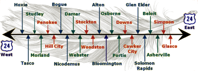
Community Kiosk Locations & Local Facts
Throughout the Solomon Valley
Scroll Down or Select and Click a Community Below to View A Specific Location  
Alton
Asherville
Beloit
Bloomington
Bogue
Cawker City
Damar
Downs
 
Glasco
Glen Elder
Hill City
Hoxie
Morland
Nicodemus
Osborne
Penokee 
Portis
Simpson
Solomon Rapids
Stockton
Studley
Tasco
Webster Res.
Woodston
See Kansas With New Eyes! - Our Eight Cultural Elements
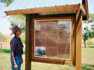
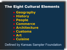
We invite you to visit our communities through the eyes of local residents using the Kansas Sampler 8 Rural Cultural Elements as a unifying lens. The information gathered and provided through each kiosk was based on these elements, that visitors would come to better know and understand each community as the locals do.
Do something different, venture off  the inter-state, enjoy the route ​your parents and grandparents traveled along U.S Highway 24!
► Download a Copy of The Kiosk Locations (PDF)
Picture
Picture
*The following community Information is organized by town from West US24 to East   
All latitude and longitude coordinates are given as North Latitude and West Longitude, in degrees, minutes and seconds. 
Community Facts are provided in PDF documents, and will open in your browser when clicked.
 
HOXIE - Community Facts ... kiosk visible from Hwy 24 [N 39° 21’ 27” & 100° 26’ 20
Kiosk is located on south side of Hwy 24 between 12th and 13th Streets in Hoxie (closer to 12th St), on west side of Sheridan County Historical Museum and Mickey’s Museum. This is the first of the 24 kiosks going east or the last going west.

TASCO - Community Facts ... kiosk visible from Hwy 24 [N 39° 21’ 24” & W 100° 18’ 08” 
Kiosk is located on south side of Hwy 24 at Tasco exit, located 0.8 miles west of Mile Marker 97 and 0.2 miles east of Mile Marker 96. Please note that all buildings in Tasco are on private property and to be viewed only from the road.

STUDLEY - Community Facts ... kiosk partly visible from Hwy 24 [N 39° 21’ 12” & W 100° 09’ 45”
At the east edge of the town of Studley, from Hwy 24, at 0.3 miles from Mile Marker 104 or 0.7 miles from Mile Marker 103, just east of fuel tanks on south side of Hwy 24, turn south on road marked “100th Ave” in Graham County and “Rd 150 E” in Sheridan County (signs on north side of Hwy 24), and go 0.1 miles south to kiosk on east side of street beside church.

MORLAND - Community Facts ... located almost a mile south of Hwy 24 [N 39° 21’ 05” & W 100° 04’ 31”
From Hwy 24, 0.4 miles west of Mile Marker 109 or 0.6 miles east of Mile Marker 108, turn south on Kansas Hwy 85 to town of Morland. Going south, cross South Solomon River at 0.7 miles and reach kiosk on east side of road in city park at 0.9 miles.

PENOKEE - Community Facts .. located almost a mile south of Hwy 24 [N 39° 21’ 03” & W 99° 58’ 22”
From Hwy 24, 0.1 miles west of Mile Marker 114 or 0..9 miles east of Mile Marker 113, turn south on Kansas Hwy 84 to town of Penokee. Going south, cross South Solomon River at 0.5 miles and reach kiosk on west side of road at 0.9 miles, near signs noting “End of Hwy 84” and “Penokee Unincorporated.”

HILL CITY - Community Facts ... kiosk visible from Hwy 24 [N 39° 21’ 03” & W 99° 51’ 24”
Kiosk is located in roadside park between two shelter houses on west edge of Hill City, north side of Hwy 24 and west of N 12th St (0.2 miles east of Mile Marker 120).  

BOGUE - Community Facts ... take the north Bogue exit at 1.0 mile (Main St.),  go south 100 yards - kiosk is on east side.        [39°, 21’, 49.13” N and 99°, 41’, 12.96” W       From Hwy 24, 0.7 miles west of Mile Marker 130 or 0.3 miles east of Mile Marker 129, turn south on Kansas Hwy 18, and follow Hwy 18 to Bogue roadside park on right. Going south, cross South Solomon River at 0.6 miles and enter park at 1.2 miles (south entrance), and go west 40 yards in park to kiosk by south shelter house.

NICODEMUS - Community Facts ... kiosk visible from Hwy 24 [N 39° 23’ 39” & W 99° 36’ 55”
Kiosk is located on frontage road on south side of Hwy 24 in roadside park, 0.6 miles west of Mile Marker 134 or 0.4 miles east of Mile Marker 133, near signs for Nicodemus and Nicodemus National Historic Site. 

DAMAR - Community Facts ... located 5 miles south of Hwy 24 [N 39° 19’ 09” & W 99° 34’ 59”
To reach Damar from Hwy 24, turn south on 2 Rd (located 0.75 miles west of Mile Marker 136 or 0.25 miles east of Mile Marker 135). Going south on 2 Rd you will cross the South Solomon River at 1.4 miles and reach Kansas Hwy 18 at 4.6 miles. At Hwy 18 turn left and go 0.55 miles to the road into Damar on the right. The kiosk is ahead of you after this turn, located beside the large “Welcome to Damar” sign. You may also reach Damar on Hwy 18 at 17 miles from Plainville or 7 miles from Bogue.

WEBSTER - ​Community Facts ... kiosk visible from Hwy 24 [N 39° 25’ 21” & W 99° 25’ 57”
...
 
STOCKTON - Community Facts ... kiosk visible from Hwy 24 [ N 39° 26’ 10” & W 99° 16’ 51”
Kiosk is in the city park on the west edge of town, south side of Hwy 24. If you are coming from the east, go 0.3 miles west of the only stoplight in Stockton. If you are coming from the west, go 0.35 miles east of Mile Marker 151. Turn south into City Park (east entrance) and the kiosk is 50 yards ahead near the east shelter house.

WOODSTON - Community Facts ... kiosk visible from Hwy 24 [N 39° 27’ 20” & W 99° 06’ 01”
Kiosk is located on the south side of Hwy 24 at the intersection with Pine Street, located 0.7 miles west of Mile Marker 163 or 0.3 miles east of Mile Marker 162 (Pine is the second street going south into town if you are coming from the west and the fourth street going south if you are coming from the east). Turn south on Pine Street and park beside kiosk on west side of Pine. Kiosk is in a small park on the south side of Hwy 24, just west of a shelter house. The turn into this park is just west of Mile Marker 144, visible from both directions. Turn south into the park and follow curve to west and park near shelter house and kiosk.

BLOOMINGTON - Community Facts ... kiosk visible from Hwy 24 [N 39° 27’ 21” & W 98° 47’ 21”

ALTON - Community Facts ... kiosk visible from Hwy 24 [N 39° 28’ 23” & W 98° 56’ 51”
Kiosk is located at north edge of Alton (formerly Bull City) on south side of Hwy 24 and east of Osborne County Road 657, at 0.25 miles west of Mile Marker 171 or 0.75 miles east of Mile Marker 170. Turn south on CR 657 and park along street to visit sign.

OSBORNE - Community Facts ... kiosk partly visible from Hwy 24 [N 39° 27’ 08” & W 98° 41’ 35”    
At junction of Hwy 24 and Hwy 281 at north edge of Osborne (located 0.5 miles south of Mile Marker 185 and 0.5 miles east of Mile Marker 184), note signs pointing to “Historical Marker” in roadside park to the east. Go east from that intersection and immediately turn south into the park, following park road approximately 0.1 miles to kiosk, located on south side of park road, across from the historical marker about the Geodetic Center of North America. ---- Kiosk located on south side of Hwy 24 at 0.6 miles west of Mile Marker 180 or 0.4 miles east of Mile Marker 179, approximately 0.1 miles east of the grain elevator.

PORTIS - Community Facts ... located nearly 4 miles from Hwy 24 [N 39° 33’ 40” & W 98° 41’ 30” 
From junction of Hwy 24 with Hwy 281 and Kansas Hwy 9, located 0.6 miles west of Mile Marker 189 or 0.4 miles north of Mile Marker 188, go north on Hwy 281 and Kansas Hwy 9 to the town of Portis. At 3.1 miles cross the North Solomon River and at 3.6 miles reach kiosk on east side of street in city park (between State St on the south and Fifth St on the north).

DOWNS - Community Facts ...​ kiosk partly visible from Hwy 24 [N 39° 30’ 32” & W 98° 32’ 29” 
Kiosk located in city park on south side of Hwy 24 in Downs, 0.5 miles from Mile Marker 197 or 0.4 miles from Mile Marker 196. Watch for signs for “Historical Marker” and “Downs City Park.” From west, turn into park at 2nd St; from east, turn into middle (second) park drive. Kiosk on south side of park drive.
...
 
CAWKER CITY - Community Facts ... kiosk visible from Hwy 24 [N 39° 30’ 34” & W 98° 26’ 00”
Kiosk located on north side of Hwy 24 in Cawker City, between Lake Dr on east and Maple St on west, across the street from the World’s Largest Ball of Twine.

GLEN ELDER - Community Facts ... kiosk partly visible from Hwy 24 [N 39° 30’ 19” & W 98° 18’ 42” 
Kiosk located south of Hwy 24 at west edge of Glen Elder, 0.75 miles from Mile Marker 210 or 0.25 miles from Mile Marker 209. Turn south from Hwy 24 to kiosk located at corner of Vine St and N Center St, approximately 50 yards from Hwy 24.

SOLOMON RAPIDS - kiosk located 1/4-mile south of Hwy 24 [N 39° 28’ 36” & W 98° 11’ 34”
From Hwy 24 turn south at Solomon Rapids exit, 0.9 miles west of Mile Marker 217 or 0.1 miles east of Mile Marker 216, and go south 0.25 miles to the small kiosk located on the west side of the road just south of the driveway at the Bill Bunger farm. This is the smallest kiosk of the 24.

BELOIT - Community Facts ... kiosk visible from Hwy 24 [N 39° 28’ 49” & W 98° 06’ 29”
Kiosk located on the north edge of Beloit on the south side of Hwy 24 in roadside park, just west of Walnut St, containing the Red School House Museum, across the highway from Sonic Restaurant. Watch for picnic table signs to indicate entrances to the park. Kiosk is on south side of park drive.

ASHERVILLE - Community Facts ... kiosk located ½-mile south of Hwy 24 [N 39° 24’ 29” & W 97° 58’ 36” 
From Hwy 24 turn south at Asherville exit onto Kansas Hwy 193, exit located 0.4 miles west of Mile Marker 230 or 0.6 miles east of Mile Marker 229, and go south 0.4 miles on Hwy 193 to sign indicating End of Hwy 193. Kiosk is at that intersection, on west side of Hwy 193.

SIMPSON - Community Facts ... kiosk located 1½ miles south of Hwy 24 [N 39° 23’ 04” & W 97° 55’ 49”
From Hwy 24 turn south at Simpson exit onto Kansas Hwy 194, exit located 0.8 miles west of Mile Marker 233 or 0.2 miles east of Mile Marker 232, and go south 1.6 miles on Hwy 194 to railroad tracks and turn west immediately after crossing railroad tracks. Go west on this street (Front St but the sign is not up at the intersection with Hwy 194) one block to kiosk located on south side of street just west of Tri-County Bank and across street east of Trappers Bar & Grill.

GLASCO - Community Facts ...​ kiosk visible from Hwy 24 [N 39° 21’ 54” & W 97° 49’ 46” 
Kiosk is located east of service station on north side of Hwy 24 at northeast corner of Glasco, 0.25 miles west of Mile Marker 239 or 0.75 miles east of Mile Marker 238. This is the first of the 24 kiosks going west or the last going east.

Picture
Contact SVHA
785-425-6881  |  E-mail SVHA


Select Below For More Information
Sheridan County
Hoxie 
Tasco
Cottonwood Ranch
Studley
Graham County
Morland
Penokee
Hill City
Bogue
Nicodemus
Rooks County
Damar
Webster State Park
Webster
Stockton
Woodston
Osborne County
Alton
Bloomington
Osborne
Portis
Downs
Mitchell County
Cawker City
Glen Elder
GE State Park
Solomon Rapids
Beloit
Asherville
Simpson
Cloud County
Glasco
Make a donation
to SVHA
​Site Updated 03-16-23
  • Click Here to Become A Member
  • Discovered a problem with our site? ► ​Email Us
Website by Limestone9 Consutling
Majority of Site Photos Courtesy of Greg German
  • Home
    • Donate
    • Site Map
  • SVHA
    • About Us
    • Our Accomplishments
    • SVHA News
    • President Message
    • Valley Voices Archive
  • Discover The Valley
    • About the Valley
    • Community Histories
    • Historical Accounts >
      • Robert McBratney
    • Water/Ways >
      • Robert McBratney
      • Bridging The Solomon
      • Water Power
      • Journeys End
      • Webster Dam
      • Ground Water Issues
      • A Sacred Promise
  • Attractions
    • Places of Interest
    • Community Kiosks >
      • Peace Pole
    • Museums
    • Libraries
    • WW II Memorial Highway >
      • Riley County
      • Clay County
      • Cloud County
      • Mitchell County
      • Osborne County
      • Rooks County
      • Graham County
      • Sheridan County
      • Thomas County
  • Amenities
    • Dining
    • Lodging
  • Locate Us
  • Membership
    • Membership Information
    • Membership Signup
    • Member List