Solomon Valley Highway 24 Alliance
  • Home
    • Donate
  • About
    • Hwy 24 Alliance
    • Our Communities
  • Attractions
    • Places of Interest
    • Community Kiosks >
      • Peace Pole
    • Museums
    • Libraries
    • WW II Memorial Highway >
      • Riley County
      • Clay County
      • Cloud County
      • Mitchell County
      • Osborne County
      • Rooks County
      • Graham County
      • Sheridan County
      • Thomas County
  • Amenities
    • Dining
    • Lodging
  • Events
    • Current
    • Upcoming
  • Locate Us
  • Membership
    • Membership Information
    • Membership Signup
    • Member List
  • Archives
    • History of SVHA
    • About the Valley
    • Our Accomplishments
    • Community Histories
    • Historical Accounts >
      • Robert McBratney
    • Water/Ways >
      • Robert McBratney
      • Bridging The Solomon
      • Water Power
      • Journeys End
      • Webster Dam
      • Ground Water Issues
      • A Sacred Promise
    • Valley Voices Archive
Living Off the Water: ​The Challenge to Tame and Sustain Life in the Solomon Valley
Shared human experiences with water along the Solomon River from Glasco to Hoxie, Kansas.

Journey's End
Alton, Kansas
Picture
Picture

A Vision
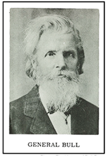
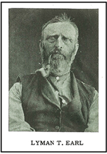
​It’s not known whether Hiram C. Bull and Lyman T. Earl were acquainted before their 1870 meeting in the fall in Cawker City.  They were both intent on settling farther west and making a name for themselves by establishing a new town after the upheaval of the Civil War.  H. C. Bull, attorney, politician, and business man, had served as quartermaster-general of Wisconsin.  Thereafter he was known as “General Bull.”  His demeanor indicated someone who would take charge in almost any situation.
Picture
Picture
Photos From: History of Bull City
​Bull and Earl joined forces to search for the site of their “Metropolis of the West.” Only two days later they came to a beautiful setting for a town; with bluffs to the south, a bend in the South Solomon River that made a wide spot in the valley, an ideal spot for their new town.   The river promised locations for a flour mill, the rolling prairie to the north promised sufficient land for the wheat, oats, and corn to be milled.

Realized
On September 12, 1870 they staked out their claims and picked out the town site.  They flipped a coin to see whether the town would be Bull City or Earlsville.  Bull won the toss and the town became Bull City (later changed to Alton).   Bull established his mercantile business in 12’ x 24’ log cabin with two rooms.

​General Bull was always interested in the wildlife found in the areas in which he lived.  He established a ten-acre wild animal park complete with deer, antelope, buffalo and elk.  Tragedy struck on October 12, 1879 when his pet elk  attacked and killed  General Bull and two hired men.  

Remembered
General Bull was well known over the state: he was the second representative of Osborne County to the state legislature.  A fine statue of an elk can be found in the new Memorial Park, reflecting the Bull City/Alton area pride in the reputation of its founder and of the wildlife he helped foster.  The Park includes a walk memorializing present and ancestral families of the area honoring those who have served their nation from the Civil War to the present time.
Picture
Photo courtesy of Deanna Roach
Picture
Photo courtesy of Carolyn Williams
October 21. Afternoon. Examined Creek – well wooded with hardwood, gooseberry, plumb (sic? and grapes. October 24. Our route brought us to the bank of the Solomon, where we noticed a low valley, on the other side... very well wooded, with cottonwood, pin oak, elm and ash.  October 24. Have found magnetian limestone fifteen feet thick, one layer being over four feet. This stone is white with a slight tinge of buff. It is ahead of the Junction stone. Also a stratum of white impure limestone, or a species of hard chalk. October 27. In the timber of the Solomon... we find the wild turkey almost as numerous as the buffalo on the prairie. October 28. The hills were nearly covered with buffalo. We have seen more today than altogether. Saw also deer, elk and antelope, also gray wolves, thousands of prairie dogs, coyotes and sage hens.
​      *from McBratney Diary Quotes – Continuity in Water/Ways Exhibit From the Original 5 x 7 inch red leather receipt book
Picture
Read More Of The Diary: 
  • Robert McBrantney Diary, 1869 Solomon Valley Expedition

Select Below to Read More Water/Ways Stories
R. McBratney  |  Bridging The Solomon  |  Water Power  |  Journeys End  |  Webster Dam  |  Ground Water Issues  |  A Sacred Promise
Picture
Contact Hwy 24 Alliance
785-425-6881  |  E-mail US

  • Click Here to Become A Member
Site Updated 02-07-25
U.S. Highway 24 Alliance logo
Discovered a problem with our site? ► ​Email Us
Make a donation to
the Hwy 24 Alliance


Website by Limestone9 Consulting
Majority of Site Photos Courtesy of Greg German

  • Home
    • Donate
  • About
    • Hwy 24 Alliance
    • Our Communities
  • Attractions
    • Places of Interest
    • Community Kiosks >
      • Peace Pole
    • Museums
    • Libraries
    • WW II Memorial Highway >
      • Riley County
      • Clay County
      • Cloud County
      • Mitchell County
      • Osborne County
      • Rooks County
      • Graham County
      • Sheridan County
      • Thomas County
  • Amenities
    • Dining
    • Lodging
  • Events
    • Current
    • Upcoming
  • Locate Us
  • Membership
    • Membership Information
    • Membership Signup
    • Member List
  • Archives
    • History of SVHA
    • About the Valley
    • Our Accomplishments
    • Community Histories
    • Historical Accounts >
      • Robert McBratney
    • Water/Ways >
      • Robert McBratney
      • Bridging The Solomon
      • Water Power
      • Journeys End
      • Webster Dam
      • Ground Water Issues
      • A Sacred Promise
    • Valley Voices Archive