Solomon Valley Highway 24 Alliance
  • Home
    • Donate
    • Site Map
  • SVHA
    • About Us
    • Our Accomplishments
    • SVHA News
    • President Message
    • Valley Voices Archive
  • Discover The Valley
    • About the Valley
    • Community Histories
    • Historical Accounts >
      • Robert McBratney
    • Water/Ways >
      • Robert McBratney
      • Bridging The Solomon
      • Water Power
      • Journeys End
      • Webster Dam
      • Ground Water Issues
      • A Sacred Promise
  • Attractions
    • Places of Interest
    • Community Kiosks >
      • Peace Pole
    • Museums
    • Libraries
    • WW II Memorial Highway >
      • Riley County
      • Clay County
      • Cloud County
      • Mitchell County
      • Osborne County
      • Rooks County
      • Graham County
      • Sheridan County
      • Thomas County
  • Amenities
    • Dining
    • Lodging
  • Locate Us
  • Membership
    • Membership Information
    • Membership Signup
    • Member List
Living Off the Water: ​The Challenge to Tame and Sustain Life in the Solomon Valley
Shared human experiences with water along the Solomon River from Glasco to Hoxie, Kansas.

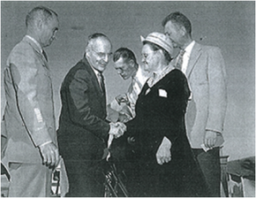
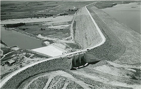
Webster Dam, Grew From A Child's Vision
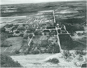
Webster, Kansas
Picture
Picture

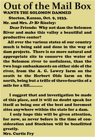
​Mrs. Curtis Fry, born Lavina Armstrong, had strong memories from childhood about blocking the South Fork of the Solomon River.  The Armstrongs farmed just below the eventual site of the Webster Dam. 

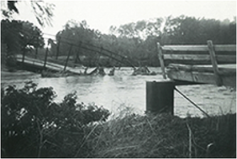
​As a child, Lavina and her sister would drive the family’s cattle to the South fork, taking shovels to dig holes in the sand, creating little pools for the cattle to drink from the next day.  On one of these trips, it occurred to Lavina, why doesn’t someone dam up the entire stream?

Lavina continued to ask that question!

October 12, 1933, Rooks County Record “Out of the Mail Box” column:  Dear Friends—“Why not dam the Solomon River and make this valley a beautiful and productive center?”
​
February, 1934, she sent letters to Governor Alfred Landon and then to George S. Knapp, chief engineer of the Kansas Water Resources Division.
Picture
It Took The Right Moment
Interest grew after long drought, then the flood of 1938—twin crusades of irrigation and flood control—locals petitioned U.S. congress, State of Kansas, and U.S. Army Corps of Engineers, supporting construction of a dam.
 
The proposed dam on South Fork was part of 1944 Pick-Sloan Missouri River Basin Plan, but there was no action until devastating floods of 1951, and need for flood control became apparent!  The Appropriation Act passed Congress in July 1951.
Picture
Picture
Picture
Further Delay
One local circumstance held up construction at Webster: the town itself.  The town of Webster was scheduled for underwater burial by the spring 1953.  Earth moving work on the dam’s foundation began March 14, 1953, but the Bureau granted a sixty day extension the following day for locals to relinquish possession of their property in order to allow Webster’s children to complete the school year in the community school house.

At Last
The finished Webster Dam is a modified homogeneous earth-fill embankment stretching for  two miles, from above resembling a bending, linear strip breaking the flatness of the Kansas plains.  An asphalt highway crosses the top of the dam.
​

Picture
Disturbing the structure’s topographic symmetry is the spillway on the left abutment.  The outlet releases water into the South fork for downstream use and for diversion into the Osborne Canal at Woodston Diversion Dam for irrigation.
 
The total capacity of the Webster Reservoir is 260,740 acre-feet, of which 183,370 acre-feet is meant for flood control, and 72,070 is slated for irrigation.  For most of its history, the reservoir has never been filled.  Periods of drought, and changes in farming practices in the upstream watershed often kept the reservoir at very low level.  Irrigation was sporadic.
Economically, this unit did not provide any monumental fiscal benefits to the towns of Rooks and Osborne Counties.  But as a barrier to hold the sometimes cloudburst of the region, Webster fulfilled one of its main objectives, flood control.
Based on excerpts from: The Webster Unit:  A Webster Lake History, by Robert Autobee, Bureau of Reclamation, 1995.
Photos on this page courtesy of Rooks County Historical Society
​October 17. Sand Creek... in Jute it was so high as to submerge houses or dug-outs of settlers, water rose in four minutes to a depth of 20 feet.   October 23. The severe weather prevented us leaving the column to go to examine the plains back of these hills, but as the buffalo keep in them, only crossing the bottom to get to the river, we conclude there is a soil there that will produce what will sustain animal life.
​     *from McBratney Diary Quotes – Continuity in Water/Ways Exhibit From the Original 5 x 7 inch red leather receipt book
Picture
Read More Of The Diary: 
  • Robert McBrantney Diary, 1869 Solomon Valley Expedition

Select Below to Read More Water/Ways Stories
R. McBratney  |  Bridging The Solomon  |  Water Power  |  Journeys End  |  Webster Dam  |  Ground Water Issues  |  A Sacred Promise
Picture
Contact SVHA
785-425-6881  |  E-mail SVHA


Select Below For More Information
Sheridan County
Hoxie 
Tasco
Cottonwood Ranch
Studley
Graham County
Morland
Penokee
Hill City
Bogue
Nicodemus
Rooks County
Damar
Webster State Park
Webster
Stockton
Woodston
Osborne County
Alton
Bloomington
Osborne
Portis
Downs
Mitchell County
Cawker City
Glen Elder
GE State Park
Solomon Rapids
Beloit
Asherville
Simpson
Cloud County
Glasco
Make a donation
to SVHA
​Site Updated 03-16-23
  • Click Here to Become A Member
  • Discovered a problem with our site? ► ​Email Us
Website by Limestone9 Consutling
Majority of Site Photos Courtesy of Greg German
  • Home
    • Donate
    • Site Map
  • SVHA
    • About Us
    • Our Accomplishments
    • SVHA News
    • President Message
    • Valley Voices Archive
  • Discover The Valley
    • About the Valley
    • Community Histories
    • Historical Accounts >
      • Robert McBratney
    • Water/Ways >
      • Robert McBratney
      • Bridging The Solomon
      • Water Power
      • Journeys End
      • Webster Dam
      • Ground Water Issues
      • A Sacred Promise
  • Attractions
    • Places of Interest
    • Community Kiosks >
      • Peace Pole
    • Museums
    • Libraries
    • WW II Memorial Highway >
      • Riley County
      • Clay County
      • Cloud County
      • Mitchell County
      • Osborne County
      • Rooks County
      • Graham County
      • Sheridan County
      • Thomas County
  • Amenities
    • Dining
    • Lodging
  • Locate Us
  • Membership
    • Membership Information
    • Membership Signup
    • Member List